A flooded street is seen in downtown as Hurricane Ian makes landfall in southwestern Florida, in Fort Myers, Florida, U.S. September 28, 2022.
Marco Bello | Reuters
Florida woke up Thursday to the catastrophic aftermath of Hurricane Ian.
Ian, one of the most powerful storms to ever hit the United States, wreaked havoc across the state, cutting power to 2.5 million customers, leaving several hospitals without water and trapping thousands of residents in their homes.
related investing news
Officials said it would take days or longer to assess the total destruction of the storm.
Fort Myers Mayor Kevin Anderson told NBC’s “TODAY” show that Ian was one of the most ferocious storms he had witnessed in decades, gutting him emotionally.
“Watching the water from my condo in the heart of downtown, watching that water rise and just flood out all the stores on the first floor, it was heartbreaking,” Anderson said.

Photos and videos on social media showed scenes of devastation: Orlando inundated by floodwater, boats wrecked in Fort Myers, trees snapped like toothpicks in Punta Gorda. Part of the Sanibel Causeway was destroyed, blocking vehicles from crossing the bridge.
The storm’s first likely casualty was a man in Deltona who drowned overnight after authorities said he went outside during the storm to drain his pool.
Florida Gov. Ron DeSantis said the storm would rank as “one of the top five hurricanes to ever hit the Florida peninsula.”
Ian was downgraded to a tropical storm Thursday morning, and President Joe Biden declared a major disaster, freeing up federal aid to assist with local and state recovery efforts.
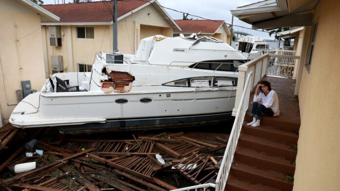
Brenda Brennan sits next to a boat that pushed against her apartment when Hurricane Ian passed through the area on September 29, 2022 in Fort Myers, Florida.
Joe Raedle | Getty Images
Ian had maximum sustained winds of near 65 mph with higher gusts early Thursday as it moved slowly through central Florida on its way to the western Atlantic, according to the National Hurricane Center.
Para información en español de Noticias Telemundo haga click aquí
Ian made landfall near Cayo Costa around 3 p.m. Wednesday as a powerful Category 4 hurricane with 150 mph winds, forecasters said.
Around 2.5 million customers in Florida were without power early Thursday after Ian struck the state’s western coast, causing a path of destruction as it moved toward the Atlantic Ocean.
Boats are pushed up on a causeway after Hurricane Ian passed through the area on September 29, 2022 in Fort Myers, Florida. T
Joe Raedle | Getty Images
Lee County Manager Roger Desjarlais said Wednesday evening the damage is extensive in the county, which includes Cayo Costa, Fort Myers and Cape Coral. The full scope of the impact was not known as the storm and winds still raged.
Rescue crews were forced to wait for conditions to improve before going to the aid of people stranded by high water.
In Lee County, there were also reports of vehicles “floating out into the ocean,” but Sheriff Carmine Marceno said officials were not able to investigate or respond to calls of people trapped until winds dropped below 45 mph.
“Those that are in need: We want to get to you, and we will get to you as soon as possible,” he said in a video address shortly before 8 p.m.
At least nine hospitals in Lee County “have no water” after the storm made landfall on Florida’s southwest coast, Federal Emergency Management Agency Administrator Deanne Criswell said Thursday.
Terry Mazany hunkered down on the 22nd floor of a Fort Myers high-rise with his wife and his 91-year-old mother as the water rose and winds whipped the building.
“We are trapped. There is eight feet of water around us,” Mazany, who moved to Florida from California a year ago, told MSNBC. He noted that the elevators were also shut down.
“It started relatively manageable but the last 12 hours we have dealt with that freight train of 100-plus mile an hour winds shaking the building, swaying,” he said.
Gusts from Hurricane Ian hit in Punta Gorda, Florida on September 28, 2022.
Ricardo Arduengo | Afp | Getty Images
Though Ian was expected to continue to weaken, the hurricane center cautioned that it could be near hurricane strength when it moved over Florida’s east coast Thursday.
Central and northeast Florida could get 20 inches of rain, and life-threatening storm surge remained a risk for parts of Florida’s western and eastern coasts, the hurricane center said.
Florida’s Atlantic coast from northeast of Orlando into Georgia could see storm surge of 6 feet, it said.
Radar indicated that 4 to 5 inches of rain per hour was falling in the hurricane’s heavier bands Wednesday, said Jamie Rhome, acting director of the hurricane center.
“Those are incredibly heavy rainfall rates,” Rhome said Wednesday night on MSNBC. The storm’s slow speed was prolonging the damaging wind but also increasing the potential for flooding, he said.
The tracking website poweroutage.us put the number of Florida customers without electricity at more than 2.5 million early Thursday.
The hurricane is forecast move across central Florida and be over the Atlantic Ocean later Thursday.
But it then will likely turn north and approach the northeastern Florida, Georgia and South Carolina coasts Friday, according to the hurricane center.
The governors of Georgia, South Carolina and North Carolina have declared states of emergency ahead of the storm’s arrival.


